- Home
- Florida Road Trip
- Old Florida Towns St Johns River
OLD FLORIDA TOWNS ON THE
ST JOHNS RIVER
By Mike Miller Updated August 11, 2023
The St. Johns River is the longest river in Florida. It is one of only a few rivers in the United States that flows from south to north.

The river begins in the swampy areas of western Indian River County near Blue Cypress Lake.

The St. Johns has been part of Florida's history since the early days, and it passes through 18 different counties on its slow journey north to the ocean.
Here are some Florida cities and towns that have been part of that history.
I've arranged them in the same order as you would see them if you are journeying upstream from the Atlantic Ocean southward to Sanford in the Orlando metro area.
MAYPORT is located at the Atlantic Ocean mouth of the St Johns River. It is a working fishing village and its lighthouse was built in 1858. Click on the photo for more about Mayport.

JACKSONVILLE is the most culturally southern large city in Florida and has been a major seaport since the earliest days. It is only 25 miles south of the Georgia border. Click on the photo for more about Jacksonville.

ORANGE PARK is a small town on the west bank of the St. Johns River south of Jacksonville. It is a suburb of Jacksonville, and was originally founded in the hopes of establishing a citrus industry. The Great Freeze of 1894-1895 ended that dream. The town is home to Moosehaven, a retirement community for members of The Loyal Order of Moose.

MANDARIN is on the east bank of the St. Johns River not far south of Jacksonville. It is on scenic State Road 13. It is famous as the Florida home of Harriet Beecher Stowe, the author of "Uncle Tom's Cabin". Click on the photo for more about Mandarin.

SWITZERLAND is a small community on State Road 13 south of Mandarin on the east side of the St. Johns River. It is near Fruit Cove and Julington Creek. It is on the former site of Switzerland Plantation. There was a general store there until recent years where old timers loved to sit on the porch and swap stories.

PICOLATA is a place name on State Road 13 south of Jacksonville that marks the spot of what was once a bustling little town. It began life as Fort Picolata, a fort built by the Spanish in the 18th century. It also served the Americans later during the Seminole Wars. The fort was chosen here because the St. Johns River narrows at this location. A ferry ran between the west bank of the St. Johns to Picolata on the east bank. It was located where State Road 13 intersects with County Road 208. That road leads directly into St. Augustine.


TOCOI is a ghost town and place name on the east bank of the river 15 miles west of St. Augustine. In the days before the Civil War, a railroad ran from the river to St. Augustine. It was mule powered, but after the Civil War it was updated with steam engines and steel rails.

GREEN COVE SPRINGS is a quiet town that was an early resort for northerners. In 1947, 600 major U.S. Navy ships were mothballed at specially constructed docks on the river. Click on the photo for more about Green Cove Springs.

PALATKA is located at a sharp bend in the river that is the unofficial boundary between "upriver" and "downriver". Its name is derived from the Seminole word for "cow crossing". Palatka is one of the oldest cities in Florida due to its strategic location on the river. It's where the big boats had to stop because the water got to shallow further upstream. Click on the photos for more about Palatka.


FEDERAL POINT and EAST PALATKA are on the east bank of the St. Johns River across from Palatka. Corky Bell's Seafood Restaurant is on the river in East Palatka.

SAN MATEO is on the river south of East Palatka and is at the intersection of US-17 and State Road 100. It is near the ghost town of Rollestown, where an agricultural colony was established in 1767. It failed economically, and all that is left now is a historic marker.

SATSUMA has a shoreline on the river that is mostly swampy, but has a nice 55+ mobile home community on the river and a cute little winery nearby. Click on photo for more about Log Cabin Winery.

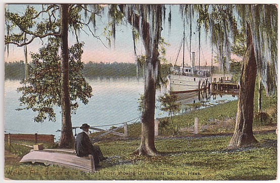
WELAKA is on the east bank of the river and is a favorite fishing spot for locals and tourists. About 600 people live in this village. There are several good places to stay, including Welaka Lodge. Click on photo for more about Welaka.

GEORGETOWN is at narrow part of the St. Johns River on its east bank. It is near Drayton Island and the Fort Gates Ferry. Click on photo to read more about the Fort Gates Ferry.

CRESCENT CITY is on Crescent Lake that is connected to the St. Johns River by Dunn's Creek. The lake offers some great fishing. The little town is east of Georgetown and Welaka in the heart of some real nice country. Click on the photo for more about Crescent City.

ASTOR is an unincorporated village on State Road 40 as it crosses the St Johns River. It is on the west bank in Lake County. The unincorporated settlement along the east bank is in Volusia County and is officially known as Volusia. Most folks call both sides of the river Astor. Click on the photo for more about Astor.

DELAND is the home of Stetson College. It is not actually on the river, but the area west of town is close by and has a DeLand address. This location has fish camps, marinas, and restaurants with access to the St. Johns River. Click on photo for more about DeLand.

DEBARY has eastern and southern city limits that touch the St. Johns River and Lake Monroe. It was the home of Frederick deBary, a wine merchant from New York who settled here. His lodge, called DeBary Hall, is a museum now on the National Register of Historic Places.

ENTERPRISE is on the north shore of Lake Monroe across from Sanford. In the old days, the steamers would end their trip here because the water gets really shallow upstream. In the old days there was a railroad that ran east to Titusville. Click on photo for more about Enterprise.

SANFORD is 22 miles north of Orlando on Lake Monroe, a wide spot on the St Johns River. The river gets shallow upstream of the lake. Upstream in this case is south, because the St Johns is a north-flowing river. Sanford is a wonderful little waterfront city. Click on the photo for more about Sanford.

Our Facebook page has more than 130,000 followers who love off the beaten path Florida: towns, tourist attractions, maps, lodging, food, festivals, scenic road trips, day trips, history, culture, nostalgia, and more. We post articles every day. Please check it out and if you like it, we would appreciate a "like" from you.
By Mike Miller, Copyright 2009-2024
Florida-Back-Roads-Travel.com
Florida Back Roads Travel is not affiliated with or endorsed by Backroads, a California-based tour operator which arranges and conducts travel programs throughout the world.
Recent Articles
-
Surfside, Florida. Home of the Famous Surf Club
Apr 24, 24 06:16 PM
 Surfside, Florida is a small town of 6,000 located between Miami Beach and Bal Harbour.