- Home
- Florida Road Trips
- Maytown Road
MAYTOWN ROAD
Pathway Through The Florida Wilderness
By Mike Miller Updated September 26, 2024
In my early days in Florida, I loved to find deserted roads around the state and just park my car at night and listen to the sounds.
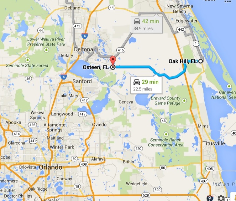 Map of Maytown Road
Birds, gators, frogs, crickets, bears. You name it, anything but city and highway sounds.
Those days of more than fifty years ago are nearly gone. The State's population has quadrupled since I moved here in 1960. It's become crowded and noisy and a traffic nightmare.
That's why it's hard to believe that just a few miles from Orlando there is a huge quiet zone that is largely unpopulated.
It doesn't really have a name. It's the vast wilderness between Deltona, Sanford and the East coast.
It is bounded roughly by State Road 415 on the west, U.S. Highway 1 on the east, the St. Johns River and State Road 46 on the south and State Road 44 on the north.
It's probably 150,000 acres more or less.

The main access through this wilderness is Maytown Road. This road starts in the small town of Osteen and heads east across Central Florida to Oak Hill on the Halifax River.
It is a lightly traveled paved road that follows the route of an old railroad that connected Enterprise to Titusville.
When I first traveled it in the 1960s it was dirt all the way. It was all too easy to get stuck during muddy conditions.
Today it's a breeze to make the drive and it's almost as quiet as it was back then.
The Florida Coast-to-Coast Trail is in the process of being completed by the side of this route.
Much of it is ready to ride and will eventually gives cyclists a 250 mile long path from St. Petersburg to Canaveral National Seashore.
There are no real towns in this wilderness. Names of old ghost towns that once existed can be found on the maps: Kalamazoo, Farmton, Cow Creek, Maytown.
Farmton's name is preserved in the Farmton Wildlife Management Area. It straddles Volusia and Brevard Counties and is 59,000 acres.
It is privately owned and is used for hunting, grazing cattle and mitigation of environmentally sensitive lands. At least as of today (2023).
Kalamazoo is a private tract of about 11,000 acres that was once planned to be a giant celery farm and self sufficient village.
Pioneers from Kalamazoo, Michigan bought the land and tried to get it started about 100 years ago.

Maytown is a ghost town that used to be a crossroads for two railroads.
One of the railroads was built in 1885 and connected Enterprise on Lake Monroe to Titusville. It was the Jacksonville, Tampa and Key West Railroad Company later purchased by the Flagler system.
The other headed down toward Lake Okeechobee and was known as the Kissimmee Valley Branch of the Flagler railroad system.
The railroad tracks are long gone and all that remains in Maytown are a few old abandoned buildings.
There is also a pioneer house south of Maytown on a road named Maytown Spur. It's along the old abandoned railroad that ran south toward Aurantia and Titusville.

Farmton operates under a conservation plan approved by federal, state and local governments.
The plan emphasizes sustainable forestry and includes measures to protect wetlands, hammocks and habitat required to preserve wildlife like black bears, bobcats, bald eagles, swallowtail kites and other Florida critters.
Farmton is owned by the Miami Corporation, a venture started more than 100 years ago by the Deering family of International Harvester fame. They still own and manage the lands.
The family also built Viscaya in Coconut Grove and the Deering Estate in Cutler Ridge, hence the Miami connection.

Turnbull Hammock forms much of the eastern border of this large area.
Much of it is also protected by conservation areas. The hammock is a huge hardwood swamp and is very difficult to access.
After you've driven through this cool quiet hammock, you will find yourself in Oak Hill. It's a good place for seafood and relaxation.
Then turn around and go back the same way.
Read more about Oak Hill and Goodrich's Restaurant.

Make sure you pull off Maytown Road now and then, turn off the car engine and just listen to the quiet. You will be amazed.
Although the route along Maytown Road is quiet, change is inevitable.
The Miami Corporation has development rights for most of this acreage and is planning an interchange at Maytown Road and I-95.
My advice: take this road trip while you can.
Maytown Road Interactive Map & Directions
From Orlando, find your way to Sanford and take State Road 46 east toward Mims. Turn left at State Road 415 and go north to Osteen.
Just after the new pedestrian and bike trail overpass, turn right at New Smyrna St. Follow it back south a block or so until you come to Florida Avenue. Turn left, go east. It becomes Maytown Road. Follow it until you get to Oak Hill.

This watercolor was made from a photo taken in August 2021. Every time I make the trip on Maytown Road, I sadly note the deterioration of the old buildings, way beyond repair or restoration.
Here is an interesting oral history video that features many of the pioneer families who lived in the area during the heyday of Maytown.
THINGS TO DO NEAR MAYTOWN, FLORIDA
Seminole Rest Historic Site
207 River Rd, Oak Hill, FL 32759
This archaeological site offers a glimpse into the lives of Native Americans and early settlers through its shell mounds and historic buildings.
Walking through the peaceful grounds, you can imagine life here hundreds of years ago. Our favorite part is the stunning view of the lagoon, perfect for quiet reflection.
Oak Hill Flea Market
357 U.S.1, Oak Hill, FL 32759 | (386) 345-3570
This bustling marketplace is a treasure hunter's dream, offering everything from fresh produce to antiques. We enjoy chatting with local vendors and discovering unique finds. It’s a great way to spend a morning and find a piece of Oak Hill to take home with you.
Mosquito Lagoon
Oak Hill, FL 32759
Renowned for redfish and trout. Numerous local charters, such as Fishing Frenzy (386) 690-0473, offer guided experiences for anglers of all levels. We enjoy the thrill of the catch and the expertise of the local guides, who know the best spots and techniques.
Mary DeWees Park
178 N. Gaines Street, Oak Hill, FL 32759 | (386) 345-3522
Mary DeWees Park is a county-run site in Oak Hill with a variety of recreational and programming facilities. The five-acre park includes two racquetball courts; a tennis, shuffleboard and basketball court; a Little League baseball field; a playground; picnic pavilions; restrooms; and a Boys and Girls Club community center.
Riverwood Park Campground
298 H H Burch Rd, Oak Hill, FL 32759 | (386) 345-3922
This campground offers a serene setting to connect with nature and camp under the stars. Our favorite sites are those along the water, where you can wake up to the sound of the lagoon.
Disappearing Island
Oak Hill, FL
Paddle or boat out to the “island”, accessible from the waters around Oak Hill. This unique sandbar emerges at low tide, offering a temporary oasis for picnics, swimming, and sunbathing.
We enjoy the adventure of timing our visit to explore this ephemeral land before it vanishes beneath the waves again.

Florida is the fastest-growing state in the United States and also the fastest-changing. If you see anything in this article that has changed or is in error, please let me know.
Thousands of Florida fans subscribe to our free daily Ezine, Florida Heritage Travel and we have 130,000 followers on Facebook.
By Mike Miller, Copyright 2009-2026
Florida-Back-Roads-Travel.com
Florida Back Roads Travel is not affiliated with or endorsed by Backroads, a California-based tour operator which arranges and conducts travel programs throughout the world.
