- Home
- Florida Towns
- Florida Ghost Towns
FLORIDA GHOST TOWNS
By Mike Miller Updated January 8, 2026
Florida ghost towns? How does a ghost town even exist in one of the fastest growing states in our country?
Many early Florida towns were located near natural resources. These communities grew up to house and support companies and people who turned the resources into products.

There were towns that relied on fishing, clams, lumber, phosphate, citrus, cattle, oysters, watermelons, celery, and other products of sea and earth.
There were also boom time towns that were really just lot sales programs.
Many of these towns barely got off the ground when they collapsed during the Florida land sale bust that preceded the Great Depression in 1929.

As natural resources were exhausted or economic depression, hurricanes, and freezes slammed into the state, many of these towns folded and mostly disappeared.
Railroads closed, highways were built that bypassed the town, other things happened that made the town only a footnote in history.
As you drive around Florida it might be fun for you to know a bit about the ghost towns you are near.
Sometimes you will see a sign or a historical marker, but usually you won't even know you are in one.
The only sign might be an old brick chimney almost invisible in thick vines and crumbling in the relentless Florida sunshine.
SOME FLORIDA GHOST TOWNS
Here are some of the ghost towns I've visited or driven by.
Acron, Aladdin City, Allenhurst, Andytown, Balm, Bamboo, Basinger, Campville, Capps, Eldora, Electra, Fort Chokonikla, Fort Dade, Fort Drum, Hampton Springs, Hilolo, Holopaw, Kerr City, Kismet, Liverpool, Manasota, Maytown, Merritt Island (many towns), Muscogee, Old Venus, Oslo, Otahite, Picolata, Pine Level, Punta Rassa, Rollestown, Tocoi, Vineland, Wacahoota, Yukon, Zion
Read more about these towns by scrolling down the page.
ACRON in Lake County was founded in the 1860s near the southern edge of the Ocala National Forest. Families lived here who farmed and worked in a sawmill and citrus groves.
The town grew to a population of about 300. The second teacher at the Acron school was Flora Call, who later got married to Elias Disney and became the mother of Walt Disney.
The community disappeared in the 1900s. The Ponceannah Cemetery near Paisley is the grave site of Walt Disney's grandparents.

ALADDIN CITY is in Miami-Dade County in the Redlands area. There is not much left to see, but in the 1920s it was a planned community designed around a Moorish theme.
The property was developed by a Michigan manufacturer of "kit" homes, designed to be shipped to Florida and erected on the site.
It had many problems, and finally folded after the hurricane and collapse of the land boom of the 1920s. There is a detailed description of this city in Wikipedia.

ALLENHURST was located on State Road 3 south of Haulover Canal on north Merritt Island. It was a popular sport fishing town that was gobbled up when NASA bought up most of the island for what would become Kennedy Space Center. The small town was demolished and the residents relocated.
 Vessel Eclectic at Allenhurst on Merritt Island, About 1910
ANDYTOWN was a tiny settlement on US-27 and State Road 84 just west of modern day Weston in Broward County. It began in 1947 as a small cafe owned by Andy Poulus.
He owned 10 acres at this intersection and a community grew up around this crossroads.
Andytown was completely demolished in 1979 to make way for the current interchange of Alligator Alley and US-27.

BALM was a small town that existed back in 1902 and has dwindled away over the years. It was located in eastern Hillsborough County a few miles east of US-301 on Balm Road.
It was a farming community and a mail pick-up point on the railroad where the train hooked the mail bag as it went by. Some pioneer families in the area included the Sweats and Hicks.
Not much remains of the town, but a church memorializes the name. Nearby are the towns of Fort Lonesome and Picnic.

BAMBOO was in Sumter County near The Villages six miles west of Leesburg on State Road 44 near Lake Deaton. It was established in 1845 by D. B. Chapman of South Carolina. About 40 families lived in the area engaged in homesteading small farms.
BASINGER in Highlands County is was named for a Fort of the same name that was built by Col. Zachary Taylor during the Second Seminole War.
It is about 10 miles northwest of Okeechobee.
A few cattle ranchers settled in the area after the wars, and the small town of Basinger was built on the Kissimmee River. The town grew and had a general store, hotels, school, church and was prosperous.
In 1915, the railroad bypassed Basinger and shipping stopped on the river. The town declined in spite of an attempt in the 1920s to redevelop the area.
The site is now owned by the South Florida Water Managment District as part of the Kissimmee River Restoration Project.
The Basinger Cemetery is located on the south side of US-08 just east of the Kissimmee River.

CAMPVILLE in Alachua County is north of the existing town of Hawthorne on US-301. It was founded by the Camp family in the mid 1800s and was located near their brick factory.
It was on the railroad, and had a sawmill, many homes, a general store, a school, and a church.
Some of the old homes and a church still stand in the former thriving little town. Many bricks can still be found in the area even today.

CAPPS is a lonely place at the intersection of US-19 and US-27 east of Tallahassee. The little town was the main headquarters of the 1,600 acre Tungston Plantation.
It became one of the largest manufacturers of tung oil in the country for use in varnish and paint.
The Asa May house is located in Capps. It was on Rosewood Plantation and is on the National Register of Historic Places. Asa May was a prominent cotton planter.

ELDORA is located in Canaveral National Seashore. Eldora was a community settled in 1876 that was home to ancient Native Americans and some pioneer settlers.
It was a steamboat stop on the Mosquito Lagoon.
The last remaining home of this community is the Eldora State House. It was built in 1913. This historic home has been restored and is open to the public.
There is a small museum with artifacts and photos.

ELECTRA was located along Marion County Road 314A on the edge of the Ocala National Forest about 4 miles south of State Road 40.
It was a settlement of several families who arrived in the area in the 1840s and 1850s. Among these families were the Sellers and Griggs.
The community was named for a character in an ancient Greek tragedy.
Most of the families were farmers, and many sold their land to the government when the Ocala National Forest was created.
The graves of many of these families are in the Electra Cemetery located on County Road 314A.

FORT CHOKONIKLA in Hardee County was located in what is now Paynes Creek Historic State Park.
The fort grew up around a trading post that provided supplies to the Seminoles in their nearby reservation.
In 1849 five Indians attacked the post and killed the clerks. Other Seminoles captured these Indians, and the Fort was built shortly thereafter.
It was abandoned in 1850 because so many soldiers died there of malaria.

FORT DADE is a ghost town on Egmont Key at the entrance to Tampa Bay. This should not be confused with the Seminole War fort near Brooksville.
The fort was built to guard the entrance to Tampa Bay during the Spanish American War. There was a town of about 300 people located on the key to support the fort.
The town is gone but the site has remains of the fort and can be visited by a ferry from Fort Desoto Park.

FORT DRUM is in Okeechobee County on US-441 between Yeehaw Junction and Okeechobee.
The name may sound familiar because it's the name of a service area on the Florida Turnpike. The ghost town is west of the Turnpike.
It was an early fort during the Second Seminole War, and was settled after the Civil War by people looking for opportunities in the cattle business.
About all that remains of this town is a cemetery where many of the early settlers are buried.
HAMPTON SPRINGS is located about 4 miles southwest of Perry on Hampton Spring Road that branches off from US-98.
It was the site of a spring that reportedly had healing properties. A hotel was built over the spring and fed an indoor pool.
A fire burned down the hotel in 1954, but the Hampton Springs Hotel Historical Site still marks the place.

HILOLO is in Okeechobee County about 5 miles south of Fort Drum. It was established in 1914 as a station on the Kissimmee Valley Branch of the Florida East Coast Railroad.
It had a school, post office and a population in 1930 of about 170.
When the railroad closed in 1946 the town faded away. Now it is a name at the intersection of US-441 and CR-68 that leads east through ranch lands to Fort Pierce.

HOLOPAW is a crossroads place in far eastern Osceola County at the intersection of US-441 and US-192. It was one of the stations along the now abandoned Florida East Coast Railway Kissimmee Valley extension.
It was large lumber town and had many company owned homes and stores. When the abundant timber resources were gone the turpentine and sawmill industries died off and the railroad shut down.
At its peak Holopaw had as many as 2,000 people.
Now there is nothing much there except a couple of convenience stores and a small restaurant, but the large development of Harmony is not far west on US-192.

KERR CITY is in Marion County and was founded in 1884. The town was a stage coach stop for travelers coming from the St. Johns River to Ocala and return.
The population was 100 at one time, and had a hotel, general store, drug store, school, church, and post office.
Before its founding it had been a cotton plantation during the Civil War. The Great Freezes of 1894 and 1895 killed all the citrus and most people moved out.
The town location is surrounded by the Ocala National Forest.

KISMET was in the Ocala National Forest near Lake Dorr. The town became prosperous and even had a 50 room hotel, but things went bad after a freeze before the turn of the century destroyed crops in the area.
The Kismet Hotel was taken apart and put back together in Eustis as the Grand View Hotel.
Walt Disney's parents were the first couple married in Lake County. The wedding took place in Kismet.
The nearby Ponceannah Cemetery is the grave site of Walt Disney's grandparents.

LIVERPOOL was a phosphate mining town located on the Peace River not far north of where it empties into Charlotte Harbor near Punta Gorda.
The town was founded in 1880 and had docks on the river, post office, stagecoach stop, hotel, and even a town newspaper.
In the early 1900s the phosphate in the area began to run out and the town folded.
MANASOTA in Charlotte County was a small town south of Venice whose main industry was the Woodmere Lumber Mill.
About 1500 people lived here and most worked in the mill. The mill provided most of the lumber that went into the construction of Venice.
A fire in 1930 wiped out the town.

MAYTOWN is in Volusia County in the vast wilderness between Sanford in the Orlando area and New Smyrna Beach. It at one time was the intersection of two railroads, now long gone.
All that remains are some crumbling old buildings and a pioneer house or two still standing in good condition.
This website features an article titled Maytown Road: Pathway Through Florida Wilderness.

MERRITT ISLAND has many ghost towns, including several that disappeared after the U.S. government purchased large acreage for Kennedy Space Center and Merritt Island National Wildlife Refuge. Here is a map that show some of them.
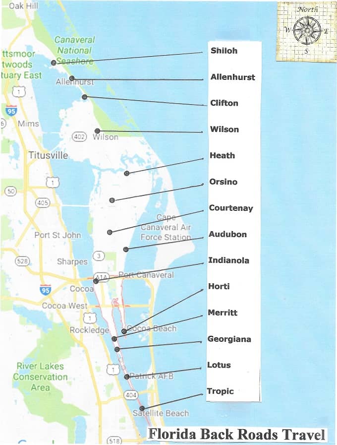 Some Ghost Towns of Merritt Island
MUSCOGEE is about 20 miles northwest of Pensacola in Escambia County. It was located along the Perdido River and was founded in 1857 as a lumber town.
The timber industry in the town employed about 1000 people in its heyday.
After much of the timber had been harvested, the town and its more than 2000 acres were sold in 1928 to a turpentine company.
The town slowly died out and is now just a memory.

OLD VENUS is in Highlands County south of Lake Placid. It was a bustling little town of ranchers, cattle raisers, farm workers, and turpentine workers.
Most of the old town burned down years ago, but there are still a few crumbling buildings in the area and several people live in newer homes among the memories of this old ghost town.

OSLO is in Indian River County south of Vero Beach. It was located near Oslo Road and US-1.
It was a town originally settled by Scandanavians, and their family names are still found in the area.
The town began as a pineapple and citrus center. When the pineapple market collapsed and the Depression came, the town died out.
Some old houses scattered about but not much else remains except the name.

OTAHITE was located in Okaloosa County near the unincorporated community of Baker.
The town grew from an Indian settlement into a trading center for crops and other products shipped through the town. The name is derived from the Indian word for "damp place."
A post office was established in 1880. The town has faded away and its location is now part of the Blackwater State Forest northeast of Pensacola.

OWANITA was a small town near Alva on the south side of the Caloosahatchee River. It was in the center of the citrus growing region that prospered many years ago. It was the site of a citrus packing plant.
 Owanita Citrus Packing Plant Employees
FloridaMemory.com
 Owanita Location Map
PICNIC is still a name on the Hillsborough County map. Sometimes the name shows as Hurrah rather than Picnic.
It was a small community at the intersection of County Road 39 and County Road 672, also known as Balm-Picnic Road.
The name comes from the fact that early settlers used to gather at this location for picnics and fish frys. The grocery store at the corner still carries the name.

PICOLATA is a place name on State Road 13 south of Jacksonville that marks the spot of what was once a bustling little town.
It began life as Fort Picolata, a fort built by the Spanish in the 18th century. It also served the Americans later during the Seminole Wars.
The fort was chosen here because the St. Johns River narrows at this location. A ferry ran between the west bank of the St. Johns to Picolata on the east bank.
It was located where State Road 13 intersects with County Road 208. That road leads directly into St. Augustine and the two cities were at one time connected by a primitive railroad.
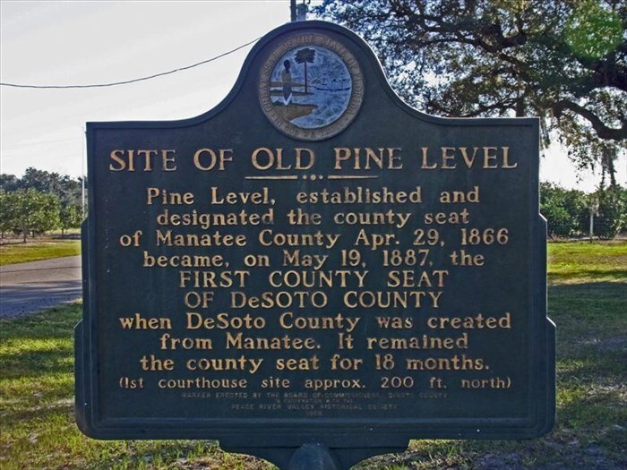
PINE LEVEL was a pioneer town noted for its frequent gun fights and general rowdy behavior.
It was the county seat of Manatee County until DeSoto County was carved out of Manatee. It then became the first county seat of the new county.
The location of the former town is 8 miles west of Arcadia on State Road 70.
PUNTA RASSA is one of those Florida places where the name still exists and people live in the area, but the old town it is named for is really gone.
It is located on the Fort Myers mainland at the bridge to Sanibel Island.
Punta Rassa was a cattle shipping town and was the biggest in Florida. The Spanish began using it in the 1500s to unload cattle from Spain in the area.
It grew to great importance during the Seminole Wars, the Civil War, and the late 1800s with Florida cattle being shipped to Cuba and other places around the world.
Cattle were driven from ranches all over Florida on trail drives to this destination. The town was filled with cattle pens, hotels, saloons, and cowboys whooping it up.
It is mentioned in many Florida histories and historical novels such as Patrick Smith's "A Land Remembered".

ROLLESTOWN is remembered today by a historic marker on US-17 along the east bank of St Johns River south of East Palatka.
Denys Rolle was a wealthy Englishman who founded the town in 1765 when Florida was still a British possession. He had extensive land holdings in the area and dreamed of developing a huge plantation in the new world.
He populated the town with indentured servants, bringing in more than two hundred of them. Some of them were criminals.
Things didn't work out because most of the servants skipped town and moved to St. Augustine or other southern cities.
He replaced them with African slaves but for a number of reasons the plantation and town failed. Most of the slaves were relocated to Rolle's holdings in Exuma, Bahamas.

STILTSVILLE is only a ghost of what it was in its heyday. It was a watery village in Biscayne Bay off Miami and Key Biscayne.
The first home on stilts was probably built in the 1930s and at its height in the 1960s and 1970s it had about 30 homes. These were weekend retreats for boating revelers.
Hurricanes and weather ate most of them up but the National Park Service keeps about seven of them around for sentimental reasons.

TOCOI is still a place name on State Road 13 on the east side of the St. Johns River.
At one time it was an actual town that was the western terminus of railroad that ran from Tocoi to St. Augustine. In the 1870s and beyond, travelers would come to Tocoi on the river as the fastest way to get to St. Augustine.
When Henry Flagler extended the railroad from Jacksonville to St. Augustine, Tocoi began to die out.
A sister ghost town across the river, West Tocoi, transferred rail passengers to Tocoi by ferry. It also faded into history.

VINELAND in Orange County has been swallowed up by Lake Buena Vista and the entire area surrounded by Walt Disney World Resort.
It was abandoned in the 1960s but earlier in the century had houses, a school, a railroad depot, a church, and a cemetery.
The cemetery is located on Fenton Street a short distance east of Apopka-Vineland Road.
Many roads in Orange County still refer to Vineland in names such as Apopka-Vineland Road, Winter Garden-Vineland Road, Kissimmee-Vineland Road, and Taft-Vineland Road.

WACAHOOTA is a large rural area near Micanopy and Williston at the junction of SW Williston Road (SR121) and SW Wacahoota Road. Its general area is in Alachua, Levy, and Marion Counties.
The name derives from the Muscogee words for "cow pen". It may also have been the site of "Bowleg's Old Plantation", named for Chief Billy Bowlegs of the Seminoles.
It was settled by planters from South Carolina in 1844 and was one of the largest places in Marion County. A post office was established earlier in 1842 and closed in 1877. Another opened in 1895 and closed in 1907.
A reminder of the town's past is in the Wacahoota Methodist Church and cemetery on State Road 121 north of its interesection with NW CR 320.
I am also reminded of my late friend Mickey who jealously kept his favorite fishing spots secret. He brought me some bass filets one day that he said he caught in Wacahoota.
 Wacahoota Methodist Church and Cemetery
YUKON is in Duval County (Jacksonville) adjacent to Naval Air Station Jacksonville. The old town was located in what is now Tillie K. Fowler Regional Park.
The community was established in the 1800s and first called "Blackpoint Settlement".
The town got modern with paved streets and modern houses, but the Navy declared it as a flight and safety hazard and the town was closed in 1963.
Quite a few old buildings remain, some abandoned and some still in use such as the Yukon Baptist Church.

ZION was a small community that was the location of the Orange Grove House of Refuge. It was located near where Atlantic Avenue in Delray Beach reaches the ocean.
There were several such shelters along the coast. This one was discontinued in 1896, and Zion was swallowed up within the growth of Delray Beach.

RESEARCH SOURCES FOR FLORIDA GHOST TOWNS
There are three websites I love for doing my ghost town research:
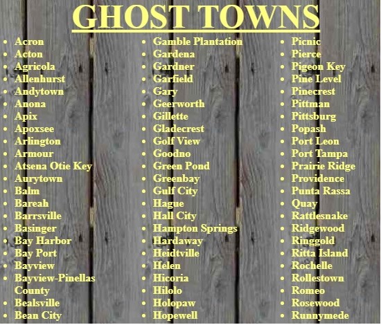
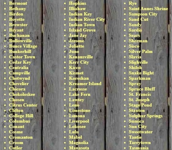
GHOST TOWNS is a website that has lists of towns and histories for each state.
They cover all of the United States including Florida and show you photos of the way it was back then and the way it is now.
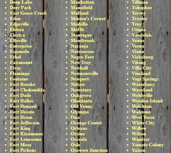
Their website lists about 250 Florida ghost towns. The site gives you more detailed information about Florida ghost towns than any other source I know about.
These screen shots from their website show the ghost towns they currently cover. To read about these ghost towns go to their website and select Florida from the map of the USA.


WIKIPEDIA LIST OF FLORIDA GHOST TOWNS is also a good source. They take the fun a step higher and give you GPS coordinates that you can use to go directly to a Google map that pinpoints the location for you.
Simply highlight the coordinates and enter into the Google search box. Viola! You will see exactly where this ghost town was.
For other kinds of ghosts, the kind that some people believe in, here is a list of haunted places in Florida.

Florida is the fastest-growing state in the United States and also the fastest-changing. If you see anything in this article that has changed or is in error, please let me know.
Thousands of Florida fans subscribe to our free daily Ezine, Florida Heritage Travel and we have 130,000 followers on Facebook.
By Mike Miller, Copyright 2009-2026
Florida-Back-Roads-Travel.com
Florida Back Roads Travel is not affiliated with or endorsed by Backroads, a California-based tour operator which arranges and conducts travel programs throughout the world.
