- Home
- Everglades
FLORIDA EVERGLADES
PAST, PRESENT and FUTURE
By Mike Miller Updated September 28, 2025
The Florida Everglades are a unique ecosystem and cultural setting. This website is your guide through the past, present, and future of the Florida Everglades.

It will take you on a trip through the ancient and modern history of this unique place.
This website was originally organized around the 8 geographic regions of Florida.
As the site evolved, however, it became evident that the Everglades are an important part of at least 3 Florida regions:
Central, Southwest and Southeast.
The economic impact of Everglades developers, especially Hamilton Disston, also affected St. Petersburg and Tarpon Springs in Central West Florida.

The Okeechobee Waterway connects the Atlantic Ocean and the Gulf of Mexico right through the heart of the Everglades.
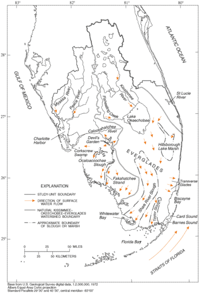
The Everglades map below is courtesy of Wikipedia. The map shows the boundaries of the Everglades and the locations of urban areas, parks and preserves that influence the environment.

THE HISTORY OF THE FLORIDA EVERGLADES
The history of the Florida Everglades can be divided into 5 general periods. Click on the links below for more detailed information.
Florida Everglades Ancient History: 13,000 BC to 1565 AD
Humans were living in the Florida Everglades area as long as 15,000 years ago.
Two major tribes - the Calusa Indians and the Tequesta Indians - lived as hunter-gatherers on the edges of the rich Florida Everglades ecosystems.
There may have been about 4,000 to 7,000 Calusa at their peak. The Tequesta were much smaller in number and occupied a smaller territory.
The Calusa were the largest and most powerful tribe in Florida, and lived in 50 settlements from Lake Okeechobee to the Gulf in Southwest Florida and the Florida Keys.
The Tequesta lived in several small settlements in Southeast Florida including one at the mouth of the Miami River at Biscayne Bay.
These Native Americans were hunter gatherers, and lived off seafood from the Gulf of Mexico and the Atlantic Ocean, and animals and plants from the nearby Florida Everglades.
The Tequesta and Calusa have disappeared from Florida.
Spanish and British Times 1565 to 1817
The Spaniards settled Pensacola and St Augustine in 1565, and owned Florida for most of the next 256 years until Florida became a U.S. territory in 1821, with a brief period of British ownership from 1763-1784.
During their ownership, the Spaniards and British didn't pay much attention to the Florida Everglades.
They considered it a god forsaken worthless land full of miserable animals and a few insignificant Indians.
The Everglades were first mentioned in writing on Spanish maps made by map makers who had never seen the land.
Their name for this mysterious area between the Atlantic Ocean and the Gulf of Mexico was "Laguna del Espiritu Santo", which means "Lake of the Holy Spirit".
The Spaniards had limited contact with the Calusa and Tequesta who lived on the outer fringes of the Florida Everglades at the mouths of rivers and streams and coastal ridges and hammocks.
Like most indigenous populations in the Americas, the Indians in Florida did not prosper under Spanish rule. The Indian populations began to decline until by the mid 1700's most of them were gone.
The Seminoles, a tribe of Creeks who assimilated other peoples - including escaped slaves - into their own, were slowly forced into migrating to Florida by development in the Carolinas and Georgia.
The Seminoles made their living in North and Central Florida until later years when they were squeezed into the Florida Everglades by the U.S. military in the Seminole Wars.
Florida Everglades and Seminole Wars 1817 to 1858
The Florida Everglades had a turbulent and violent history in the years from 1817 to 1881.
Spain still owned Florida in 1817, but the U.S. government was fighting Indians who were feuding with American settlers in Florida and south Georgia.
The First Seminole War was from 1817 to 1818. The United States acquired Florida from Spain in 1821, and it became a territory. Florida became a state in 1845.
Not much was happening in the Everglades when Florida became a state. The remote region had almost no settlement, agriculture, development or industry.
As white settlers began to move into North and Central Florida, conflicts and violence between them and the Seminole Indians became a problem that the government tried to solve by moving the Seminoles to western reservations.
The Indians didn't always want to move, so three Seminole Wars took place on Florida soil.
- The First Seminole War: 1817 to 1818.
- The Second Seminole War: 1835 to 1842.
- The Third Seminole War: 1855 to 1858.
These wars saw most of the Seminoles either killed or transplanted to reservations in the western United States.
The Seminoles never surrendered, and those that survived escaped into the Florida Everglades where their descendants still live. The Seminole Culture survived as well.
Many Florida place names date back to the old primitive fortifications of the Seminole Wars.
Some of these include Fort Lauderdale, Fort Pierce, Fort Myers, Fort Drum, Fort Ogden, Fort Meade, Fort Brooke (Tampa), Fort King, Fort Basinger and many others.
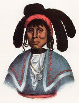 Chief Micanopy
The town of Micanopy near Gainesville was named in honor of the great war chief of the Second Seminole War.
The name is pronounced MICK-UH-NOPIE that rhymes with Opie, Sheriff Andy's son in Mayberry.
Another great leader in the Second Seminole War was Osceola. Even though not a tribal chief, he had great influence with Micanopy and the other Seminoles.
Osceola was born Billy Powell in 1804 in Alabama. Billy was apparently native American, English, Irish, Scottish and African American.
He was a one man United Nations, and his heritage may have helped him become such a great leader.
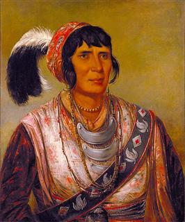 Osceola
Many surnames of Seminole origin still survive in the areas around the Florida Everglades. Some typical ones include Osceola, Billie and Bowlegs.
The Seminoles are the only Indian nation never to sign a peace treaty with the U.S.
Their legacy of never surrendering is proudly carried on by the Florida State Seminole athletic program. One of the greatest of all college football traditions takes place at home games in Doak Campbell stadium.
 Osceola and Renegade
A student portraying Osceola charges down the field riding an Appaloosa war horse named Renegade and plants a flaming spear at midfield to begin every home game.
Even this old Gator fan admits to loving the spectacle.
The U.S. Civil War took place from 1861 to 1865, and Florida was a southern state whose role was mainly providing food and other agricultural products to the battling Confederate armies further north.
The State was consumed by the War and the painful Reconstruction that followed until 1877.
The Florida Everglades remained pretty much as it had for thousands of years except for the Seminole Indians who lived off the land and waters.
The waters continued to flow in the Everglades as they had historically done and as shown on this map from Wikipedia.
All of that historic flow that had nurtured the Everglades for thousands of years was about to change.
Florida was about to enter into several economic booms that featured the Everglades as a star player.
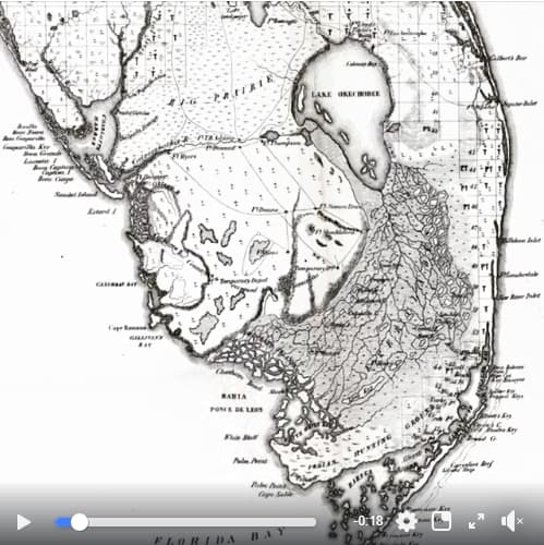
Click on the map below to see a short video of the historic flow.
Florida Everglades Reclamation/Agriculture 1881 to 1930
This period in Everglades history was all about "drain baby, drain".
In 1881 Florida was still suffering from the economic ravages of the Civil War and the Reconstruction years that followed.
Florida, along with other states of the old Confederacy, was just about broke.
The State was looking for ways to raise money for its routine operations, and for ways to encourage development and agriculture and increase its tax base.
They saw an answer in the millions of acres of "worthless" swampland it owned in the Everglades and in other undeveloped properties it owned on the west coast of Florida.
In those days, most people felt that a swamp was just a useless piece of real estate that had no value until it was drained, developed and cultivated.

In 1881, the State sold 4,000,000 acres - an area larger than Connecticut - to a northern industrialist named Hamilton Disston.
He paid 25 cents per acre, and it was apparently the largest land purchase by any single person in the history of the world.
Disston tried very hard to drain the northern Florida Everglades south of Orlando. He piled a fortune on top of his million dollar land purchase price.
He built canals and dredged rivers and opened the interior of central Florida to steamboat navigation.
He dredged the Kissimmee River south to Lake Okeechobee, then connected the big lake to the Caloosahatchee River so that steamboats could make the trip from Fort Myers to Kissimmee.
Central Florida was now connected to the world via the Gulf of Mexico.

Disston's efforts started the first land boom in Florida history. He was responsible for creating or growing Kissimmee and St. Cloud in Central Florida, and Gulfport, Tarpon Springs and St. Petersburg in Central West Florida.
He also started the successful growing and harvesting of rice and sugar cane near Kissimmee.
Most of the drainage systems installed by Disston almost 130 years ago are still functioning today in the Kissimmee-St. Cloud area. All of these efforts to drain the Everglades, however, fell short.
He was unable to significantly lower the surface water around Lake Okeechobee and in the Everglades, but his activities were the beginning of development and agriculture in the area.

His achievements made it possible for Henry Flagler to build his railroad down the east coast of Florida, for Henry Plant to build his railroad to the west coast at Tampa, and for the two railroads and their hotels help Florida develop its tourist and agriculture industries.
Another important figure in the reclamation period was Richard J. "Dicky" Bolles. In 1908, the State of Florida sold him 500,000 acres in the Everglades for $2/acre.
As part of the purchase, the State promised to spend half the sale proceeds for drainage and reclamation.
Bolles founded the Florida Fruit Lands Company to sell 180,000 acres in Dade and Palm Beach Counties.
The company subdivided the land into 12,000 farm sites of various sizes and designated a site for a new town named "Progresso".
They had plans for streets, factories, schools, churches and infrastructure.
This created another of Florida's famous land booms. For $240, buyers could purchase the right to bid on a farm and town lot through a scheduled auction.
He also used the same sales technique to sell his remaining 420,000 acres through another company of his, Okeechobee Fruit Lands Company.
His salesmen fanned out throughout the country promoting the Everglades as a "Garden of Eden", a "Tropical Paradise" and a "Promised Land".
His promotions even had the endorsement of State and Federal officials who touted the fertility of the Everglades land.

Bolle's deals began to fall apart by 1911. He held a giant auction in Fort Lauderdale, and it was only then that holders of the $240 options found out there would be no genuine auction.
Instead, they were required to buy land that had been picked out for them. Most of the land was still under water.
There were huge lawsuits, and the court let Bolles keep the deposits but wouldn't let him sell any land until the State had done its part in draining the Everglades.
In 1913 Bolles was arrested, but was found innocent. He maintained that he believed what State and Federal officials had told him about the Everglades, and that he was only acting on that information.
Bolles died in 1917, and along with him the dreams of his Everglades land buyers also died. There is no town of Progresso, the land contracts expired and most of the land Bolles sold went back to the State for nonpayment.
Florida Everglades Flood Control From 1930 to 1971
The Florida Everglades grew in population as a result of the drainage improvements completed from 1881 to 1928. Many new communities were formed in the vicinity of the Everglades in those years.
Two of the worst hurricanes in Florida history stormed ashore in 1926 and 1928 and caused Lake Okeechobee to burst through its levees, drowning thousands of people. The 1928 disaster was the worst in Florida hurricane history.
The Federal and State governments began to concentrate now on flood control rather than drainage. The Okeechobee Flood Control District was created in 1929.
Between 1930 and 1937,the U.S. Army Corps of Engineers built a 66 mile long dike around the southern edge of Lake Okeechobee.
The 20 foot high embankment was named for President Herbert Hoover. The Corps also set the legal limits of surface water elevation on the lake between 14 and 17 feet above sea level.
At the same time, an 80 foot wide 6 foot deep canal was built along the winding path of the narrow upper Caloosahatchee River.
Whenever the lake levels got too high, the excess water was released through the canal and went on down to the Gulf.
This project was part of the 1937 completion of the Okeechobee Waterway.
Sugar cane production soared after these flood control improvements, and the populations of the small towns around the lake tripled by the end of World War Two.
As soon as the Hoover dike was completed, however, people began to notice detrimental effects in the Everglades.
An extended drought in the late 1930's highlighted the problem.
The Hoover dike prevented water from leaving the lake into the surrounding lands by sheet flow. The peaty soils dried up and turned into dust.
Salty salt water from the ocean intruded into Miami's wells because the Everglades water wasn't getting there.
In 1939 a million acres of Everglades burned and the black clouds of soot from the peat and sawgrass fires made it difficult to breathe in Miami.
The low ground water levels caused the peaty soils to shrink and subside and many homes had to be put on stilts and raised up as much as 8 feet to get back to the elevations that their homes were before the dike was built.

More hurricanes in 1947 caused severe flooding, and the Central and Southern Florida Flood Control Project (C&SF) was formed to construct flood control improvements in the Everglades.
About this same time, Everglades National Park was officially dedicated in 1947.
It was a good thing for the long term protection of the Everglades, but to understand the impact on some of the local residents read Totch: A Life In The Everglades.
The C&SF built 1,400 miles of canals, numerous flood gates and pump stations and levees up until 1971.
The final project was the 22 miles long C-38 canal, which straightened the natural meandering course of the Kissimmee River on its way to Lake Okeechobee.
The C-38 project almost immediately started causing serious damage to animal and plant communities and negatively impacted the water quality in the region.
Florida Everglades Restoration: Undo What Man Has Done
The Florida Everglades was being destroyed by all of the drainage, development activity and agricultural fertilizer and wastewater runoff.
It became horrifyingly evident to thoughtful Americans that something drastic had to be done.
The issue came to a head in the early 1970's. Miami International Airport was jammed up with traffic and didn't have much room for expansion in its urban Miami location.
A proposal was submitted to construct a huge jetport in the Big Cypress Swamp.
Studies soon showed that the jetport would destroy the South Florida ecosystem and Everglades National Park.
Local governments, environmentalists, other activists and even nationally prominent politicians mobilized intense opposition to the project.
From this pivotal event, local, state and federal governments began to cooperate in finding ways to balance the needs of urban and agricultural Florida with the Everglades natural environment.
The C-38 Canal (Kissimmee River) became the first C&SF project to be restored. In the 1980's, the government began to backfill the canal. In many cases they used the original soils excavated from the river.
In 1986 high levels of phosphorous and mercury were discovered in the Everglades waterways after years of fertilizer runoff from agricultural operations. Now Florida Everglades water quality quickly became a focus.
Many legal battles were fought between various governments to decide who was responsible for monitoring and enforcing water quality standards.
Finally, in 1994, the Everglades Forever Act was passed. Since then the South Florida Water Management District (SFWMD) and the U.S. Army Corps of Engineers have cooperated in programs that have greatly reduced phosphorous levels.
Other government and private studies, however, showed that the quality of life in South Florida was in decline and that the region could not sustain its growth.
The studies predicted serious environmental decline, water shortages and a devastated tourist economy.
Finally, in 2000, after years of study and legal battles, a strategy called the Comprehensive Everglades Restoration Plan (CERP) was passed into law to restore portions of the Everglades, Lake Okeechobee, the Caloosahatchee River and Florida Bay.
CERP is a joint venture of the Federal and State governments, and is managed by the U.S. Army Corps of Engineers and the South Florida Water Management District.
It is estimated that the over 60 major projects that comprise CERP will take 30 years to complete and cost about $8 billion.
The objective of CERP is to restore as much as possible of the original water flows that historically made the Everglades the treasure it was.
The plan also has to provide flood protection for people and property.
Everybody fervently hopes that CERP will go a long way toward reversing the decline of the Everglades that has been taking place since Hamilton Disston first started his drainage projects almost 130 years ago.
The Florida Everglades is a huge subtropical wetland of sawgrass marshes in a complex system of interdependent ecosystems.
These ecosystems include cypress swamps, the estuarine mangrove forests of the Ten Thousand Islands, tropical hardwood hammocks, pine rockland, and the salt water marine environment of Florida Bay in the Keys.
The complexity and uniqueness of its history and ecology made it evident that it deserved to be treated as its own region on our website. There will be some overlap on this website, of course.
For example, the western parts of the extremely urban southeast Florida counties of Martin, Palm Beach, Broward and Miami-Dade are in the Everglades.
The rampant development in this megalopolis has created new problems for the Everglades and aggravated old ones.
Also, although Naples, Fort Myers, Labelle, Immokalee and Everglades City are in southwest Florida, the Everglades touches their very back doors and is part of their history.
The Florida Everglades sprawls across 16 counties, all the way from Orlando in the north to Monroe County in the south. It was the last region of Florida to see significant development, but when it did it happened with a vengeance.
The centerpiece of the Everglades is shallow Lake Okeechobee, the second largest freshwater lake completely within the boundaries of the 48 continental United States. The largest is Lake Michigan.
Historically, the areas north of Lake Okeechobee drained into the lake via natural waterways including the Kissimmee River.
When the water levels in Lake Okeechobee built up, the overflows traveled slowly south through the marshes and sloughs to Florida Bay, the salt water body that separates mainland Florida from the Keys.
This area south of Lake Okeechobee, about 60 miles wide and 100 miles deep, was coined "The River of Grass" by Marjorie Stoneman Douglas in her book of the same name.
This sheet flow moved south at about 1/2 mile per day. Sometimes it would take two summer rainy seasons before the water would make it to Florida Bay.
This long journey was essential to the balance of the Everglades ecology, and to the purification of storm water before it soaked back into the ground or found its way to the bay.
Most of south Florida relies on the Everglades and its recharged water for their drinking water supply.
One of the oldest and most active Everglades advocacy organizations is Friends of the Everglades.
Florida Towns Influenced by the Everglades
Many towns and cities in south Florida are influenced by the Florida Everglades and Lake Okeechobee.
This influence is felt by towns not just in the Everglades, but along the southeast and southwest coasts of Florida.
These towns, if not quite in the Everglades, are close to it, affect it and are affected by it.
A low ridge separates the Everglades from the Atlantic Ocean, and the areas between the ocean and the ridge were developed first.
Henry Flagler built his Florida East Coast Railroad along this ridge. As the areas grew in population, they sprawled west into the Everglades.
The southwest Florida coast developed later because there was no easy way to cross the Everglades from southeast Florida. The Tamiami Trail, completed in 1928, opened up southwest Florida to development.
Towns that didn't exist or start growing until the draining of the Everglades include:
Belle Glade, Canal Point, Clewiston, Everglades City, Lakeport, Moore Haven, Okeechobee, Pahokee, Port Mayaca, St. Cloud and South Bay.
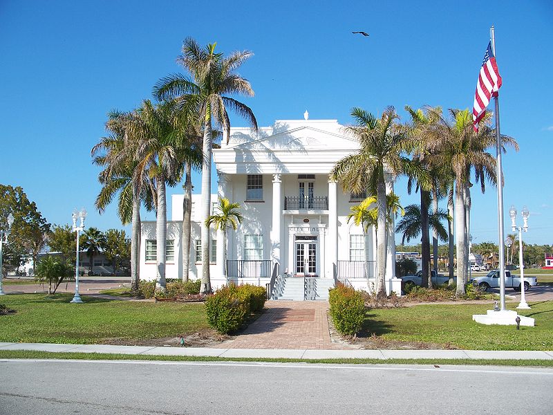 Everglades City City Hall
Many southeast Florida towns have had their western suburbs carved out of the Florida Everglades. West Palm Beach, Fort Lauderdale and Miami are notable examples along with most of the towns in between.
If you are interested in learning more about the Florida Everglades, its past, present and future, I recommend reading"THE SWAMP: The Everglades, Florida, and the Politics of Paradise" by Michael Grunwald.
Things To Do In The Florida Everglades
There are many things to do in the Florida Everglades towns including ecotourism, fishing, gambling at the Indian casinos, airboat rides, watching alligator wrestling and a host of other activities that will be expanded as this website continues to grow.
The The Okeechobee Waterway provides one of the most interesting side trips in this part of the country. You can enjoy it by boat or at the several recreational areas adjacent to the locks and dams along the route.
A fun place is Big Cypress Loop Road and Lucky Cole's place. Lucky Cole is the well known Everglades photographer who specializes in nude photos of women in tropical settings.
Here are some recommended Everglades day trips and adventures.

Another famous resident of the Loop Road back in the day was Ervin Rouse, the composer of the classic country fiddle tune, "The Orange Blossom Special".
If you want to hear an unusual and beautiful rendition of this classic, click on the video above. It was performed on Ocean Avenue in South Beach, only an hour or so east of Loop Road.
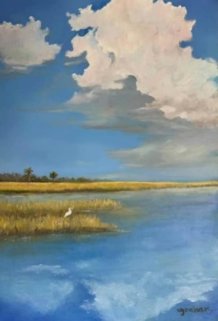 Alone In My Home
Lauren Graham Cunningham
Many artists have been inspired by the Florida Everglades and tried to capture its magic on canvas.
This one is by artist Lauren Graham Cunningham of Mount Dora, Florida.
I like her capture of the vast marshes, the blue skies, the blue water, the distant hammock, and the lonely bird enjoying the solitude.
The bird is alone in its home.

Florida is the fastest-growing state in the United States and also the fastest-changing. If you see anything in this article that has changed or is in error, please let me know.
Thousands of Florida fans subscribe to our free daily Ezine, Florida Heritage Travel and we have 130,000 followers on Facebook.
By Mike Miller, Copyright 2009-2026
Florida-Back-Roads-Travel.com
Florida Back Roads Travel is not affiliated with or endorsed by Backroads, a California-based tour operator which arranges and conducts travel programs throughout the world.
